from machine import Pin,I2C,UART
import time
import _thread
from ssd1306 import SSD1306_I2C
import math
utcCorrect = 3
earthRadius = 6371000
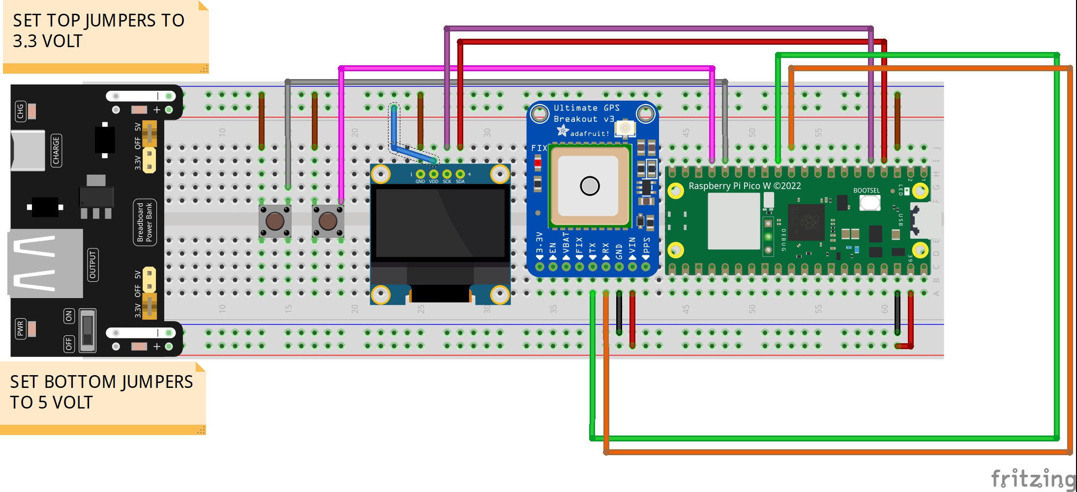
i2c2 = I2C(1, sda=Pin(2), scl=Pin(3), freq=400000)
dsp = SSD1306_I2C(128,64,i2c2)
sysState = 0
dataLock = _thread.allocate_lock()
keepRunning = True
GPS = UART(1, baudrate=9600, tx=machine.Pin(8), rx=machine.Pin(9))
# Reset GPS
GPS.write(b'$PMTK314,-1*04\r\n')
#The following line ensures that the GPS reports the GPVTG NMEA Sentence
GPS.write(b"$PMTK314,0,1,1,1,1,1,1,0,0,0,0,0,0,0,0,0,0,0,0*28\r\n")
NMEAdata = {
'GPGGA' : "",
'GPGSA' : "",
'GPRMC' : "",
'GPVTG' : ""
}
GPSdata = {
'latDD' : 0,
'lonDD' : 0,
'heading' : 0,
'fix' : False,
'sats' : 0,
'knots' : 0,
'time' : '00:00:00',
'date' : '00/00/0000',
'alt' : 0.0
}
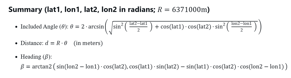
def calculateDistance(lat1,lon1,lat2,lon2):
lat1=lat1*2*math.pi/360
lon1=lon1*2*math.pi/360
lat2=lat2*2*math.pi/360
lon2=lon2*2*math.pi/360
theta = 2*math.asin(math.sqrt(
math.sin((lat2-lat1)/2)**2 +
math.cos(lat1)*math.cos(lat2)*math.sin((lon2-lon1)/2)**2
))
distance = earthRadius * theta
return distance
def calculateHeading(lat1,lon1,lat2,lon2):
lat1=lat1*2*math.pi/360
lon1=lon1*2*math.pi/360
lat2=lat2*2*math.pi/360
lon2=lon2*2*math.pi/360
deltaLon=lon2-lon1
xC=math.sin(deltaLon)*math.cos(lat2)
yC=math.cos(lat1)*math.sin(lat2)-math.sin(lat1)*math.cos(lat2)*math.cos(deltaLon)
beta = math.atan2(xC,yC)
betaDeg = beta*360/2/math.pi
return betaDeg
def gpsThread():
print("Thread Running")
global keepRunning,NMEAdata
GPGGA = ""
GPGSA = ""
GPRMC = ""
GPVTG = ""
while not GPS.any():
pass
while GPS.any():
junk = GPS.read()
print(junk)
myNMEA = ""
while keepRunning:
if GPS.any():
myChar=GPS.read(1).decode('utf-8')
myNMEA = myNMEA + myChar
if myChar == '\n':
myNMEA = myNMEA.strip()
if myNMEA[1:6] == "GPGGA":
GPGGA = myNMEA
if myNMEA[1:6] == "GPGSA":
GPGSA = myNMEA
if myNMEA[1:6] == "GPRMC":
GPRMC = myNMEA
if myNMEA[1:6] == "GPVTG":
GPVTG = myNMEA
if GPGGA != "" and GPGSA!="" and GPRMC!="" and GPVTG!="":
dataLock.acquire()
NMEAdata = {
'GPGGA' : GPGGA,
'GPGSA' : GPGSA,
'GPRMC' : GPRMC,
'GPVTG' : GPVTG
}
dataLock.release()
myNMEA = ""
print("Thread Terminated Cleanly")
def parseGPS():
readFix=int(NMEAmain['GPGGA'].split(',')[6])
if readFix !=0:
GPSdata['fix'] = True
latRAW = NMEAmain['GPGGA'].split(',')[2]
latDD = int(latRAW[0:2]) + float(latRAW[2:])/60
if NMEAmain['GPGGA'].split(',')[3] == 'S':
latDD = -latDD
GPSdata['latDD']= latDD
lonRAW=NMEAmain['GPGGA'].split(',')[4]
lonDD=int(lonRAW[0:3]) + float(lonRAW[3:])/60
if NMEAmain['GPGGA'].split(',')[5] == 'W':
lonDD = -lonDD
GPSdata['lonDD'] = lonDD
heading = float(NMEAmain['GPRMC'].split(',')[8])
GPSdata['heading'] = heading
knots = float(NMEAmain['GPRMC'].split(',')[7])
GPSdata['knots'] = knots
sats = int(NMEAmain['GPGGA'].split(',')[7])
GPSdata['sats'] = sats
utcTime = NMEAmain['GPGGA'].split(',')[1]
utcDate = NMEAmain['GPRMC'].split(',')[9]
# utcTime = "013445.000"
# utcDate = "010125"
# Extract year from UTC date (format: DDMMYY), prepend '20' for full year (e.g., '25' → '2025')
myYear = '20' + utcDate[4:]
# Extract month from UTC date (e.g., '01' for January)
myMonth = utcDate[2:4]
# Extract day from UTC date (e.g., '01' for 1st)
myDay = utcDate[0:2]
# Calculate hours by adding UTC offset to UTC hours, convert to string
myHours = str(int(utcTime[0:2]) + utcCorrect)
# Extract minutes from UTC time (e.g., '34' from '013445.000')
myMin = utcTime[2:4]
# Extract seconds from UTC time (e.g., '45' from '013445.000')
mySec = utcTime[4:6]
# Define array of maximum days per month (index 0-11 for months 1-12: Jan to Dec)
maxDays = ['31', '28', '31', '30', '31', '30', '31', '31', '30', '31', '30', '31']
# Check if year is a leap year (simplified: divisible by 4); if so, set February to 29 days
if int(myYear) % 4 == 0:
maxDays[1] = '29'
# Check if hours exceed 24 (for positive UTC offsets, e.g., UTC 22:00 + 5 = 27:00)
if int(myHours) >= 24:
# Subtract 24 from hours to wrap around to next day (e.g., 27 → 3)
myHours = str(int(myHours) - 24)
# Pad hours with leading zero if single digit (e.g., '3' → '03')
if len(myHours) < 2:
myHours = '0' + myHours
# Increment day to account for crossing midnight (e.g., 30 → 31)
myDay = str(int(myDay) + 1)
# Check if day exceeds maximum days for the current month (e.g., June 31 > 30)
if int(myDay) > int(maxDays[int(myMonth) - 1]):
# Reset day to 1 for the next month
myDay = '01'
# Increment month (e.g., June → July)
myMonth = str(int(myMonth) + 1)
# Check if month exceeds 12 (e.g., December → January)
if int(myMonth) > 12:
# Reset month to January
myMonth = '01'
# Increment year (e.g., 2025 → 2026)
myYear = str(int(myYear) + 1)
# Pad day with leading zero if single digit (e.g., '1' → '01')
if len(myDay) < 2:
myDay = '0' + myDay
# Pad month with leading zero if single digit (e.g., '7' → '07')
if len(myMonth) < 2:
myMonth = '0' + myMonth
# Check if hours are negative (for negative UTC offsets, e.g., UTC 01:00 - 5 = -4)
if int(myHours) < 0:
# Add 24 to hours to wrap around to previous day (e.g., -4 → 20)
myHours = str(int(myHours) + 24)
# Pad hours with leading zero if single digit (e.g., '3' → '03')
if len(myHours) < 2:
myHours = '0' + myHours
# Decrement day to account for crossing midnight backward (e.g., 01 → 00)
myDay = str(int(myDay) - 1)
# Check if day is less than 1 (e.g., January 1 → December 31)
if int(myDay) < 1:
# Decrement month (e.g., January → December)
myMonth = str(int(myMonth) - 1)
# Check if month is less than 1 (e.g., January → December of previous year)
if int(myMonth) < 1:
# Set month to December
myMonth = '12'
# Decrement year (e.g., 2025 → 2024)
myYear = str(int(myYear) - 1)
# Set day to maximum days of the new month (e.g., December → 31)
myDay = maxDays[int(myMonth) - 1]
# Pad day with leading zero if single digit (e.g., '1' → '01')
if len(myDay) < 2:
myDay = '0' + myDay
# Pad month with leading zero if single digit (e.g., '7' → '07')
if len(myMonth) < 2:
myMonth = '0' + myMonth
# Combine hours, minutes, seconds into time string (e.g., '20:34:45')
myTime = myHours + ':' + myMin + ':' + mySec
# Combine month, day, year into date string (e.g., '12/31/2024')
myDate = myMonth + '/' + myDay + '/' + myYear
# Store local time in GPSdata dictionary
GPSdata['time'] = myTime
# Store local date in GPSdata dictionary
GPSdata['date'] = myDate
GPSdata['alt'] = float(NMEAmain['GPGGA'].split(',')[9])
def dispOLED():
global sysState,latitude1,longitude1,latitude2,longitude2
dsp.fill(0)
if GPSdata['fix'] == False:
dsp.text("Waiting for Fix . . .",0,0)
if GPSdata['fix'] == True:
if sysState%5== 0:
dsp.fill(0)
dsp.text("Ultimate GPS",0,0)
dsp.text(GPSdata['date'][0:5] + ' '+GPSdata['time'],0,16)
dsp.text("LAT: "+str(GPSdata['latDD']),0,26)
dsp.text("LON: "+str(GPSdata['lonDD']),0,36)
dsp.text("SATS: "+str(GPSdata['sats']),0,46)
if sysState%5==1:
latitude1=GPSdata['latDD']
longitude1=GPSdata['lonDD']
sysState = 2
if sysState%5==2:
dsp.fill(0)
dsp.text("Ultimate GPS",0,0)
dsp.text(GPSdata['date'][0:5] + ' '+GPSdata['time'],0,16)
dsp.text("P1 lat "+str(latitude1),0,26)
dsp.text("P1 lon "+str(longitude1),0,36)
dsp.text("Proceed to P2",0,46)
dsp.text("Then Press Btn",0,56)
if sysState%5==3:
latitude2=GPSdata['latDD']
longitude2=GPSdata['lonDD']
sysState=4
if sysState%5==4:
dsp.fill(0)
dsp.text("Ultimate GPS",0,0)
dsp.text(GPSdata['date'][0:5] + ' '+GPSdata['time'],0,16)
dist=calculateDistance(latitude1,longitude1,latitude2,longitude2)
head=calculateHeading(latitude1,longitude1,latitude2,longitude2)
dsp.text("Dist: "+str(dist),0,26)
dsp.text("Head: "+str(head),0,36)
dsp.show()
butOnePin = 12
butOne = Pin(butOnePin, Pin.IN, Pin.PULL_UP)
butOneUp = 0
butOneDown = 0
butOneOld = 1
def butOneIRQ(pin):
global butOneUp,butOneDown,butOneOld,sysState
butOneValue = butOne.value()
if butOneValue==0:
butOneDown=time.ticks_ms()
if butOneValue==1:
butOneUp = time.ticks_ms()
if butOneOld==1 and butOneValue==0 and butOneDown-butOneUp>50:
sysState = sysState + 1
print('Button One Triggered')
butOneOld=butOneValue
butOne.irq(trigger=Pin.IRQ_FALLING | Pin.IRQ_RISING , handler = butOneIRQ)
_thread.start_new_thread(gpsThread,())
time.sleep(3)
try:
while True:
dataLock.acquire()
NMEAmain = NMEAdata.copy()
dataLock.release()
parseGPS()
if GPSdata['fix'] == False:
print("Waiting for Fix . . .")
if GPSdata['fix'] == True:
print("Ultimate GPS Tracker Report: ")
print(GPSdata['time'],GPSdata['date'])
print("Lat and Lon: ",GPSdata['latDD'],GPSdata['lonDD'])
print("Knots: ",GPSdata['knots'])
print("Heading: ",GPSdata['heading'])
print("Elevation: ",GPSdata['alt'])
print("Sats: ",GPSdata['sats'])
print()
dispOLED()
time.sleep(1)
except KeyboardInterrupt:
print("\nStopping Program . . . Cleaning Up UART")
keepRunning = False
time.sleep(1)
GPS.deinit()
time.sleep(1)
dsp.fill(0)
dsp.show()
print("Exited Cleanly")